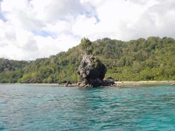
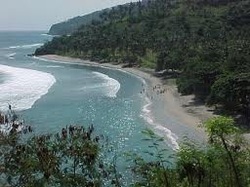
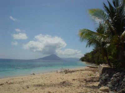
 Banda Neira or Banda Naira is one of the island in Kepulauan Banda (Banda Archipelago) - Maluku. Its an old city who had memory and be part of unforgetable international history, known as “een klein Europeesche Stad in Zuid-Oost Azie", which mean a group of european cities in southeast Asia. Banda has a beautiful scenery that bring peacefull thought. Jacques Causteau, said that seeing Banda Neira is like inventing a new heaven. In the map, Banda archipelago just like sprinkling of black rice on the southeast side of Ambon island. In his diary, Francisco Serrau, said “We sailed from Malaka on November 11, 1951 on the west wind season. By that time, we did not had enough stock since war with Malay Sultan still occured. Within 2 months sailing, we running out of stock. To survive, we have to eat everything we found in the ship, cocroach, mouse, and stinky cheese for instant. In the middle of Januari 1512, we arrived at beautiful Banda Neira. So many adventurer try to discovered this heavenly island, rich with nutmeg, but we contributed to our success to find it”.
Underwater Banda Sensation
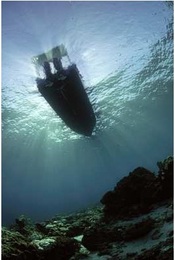
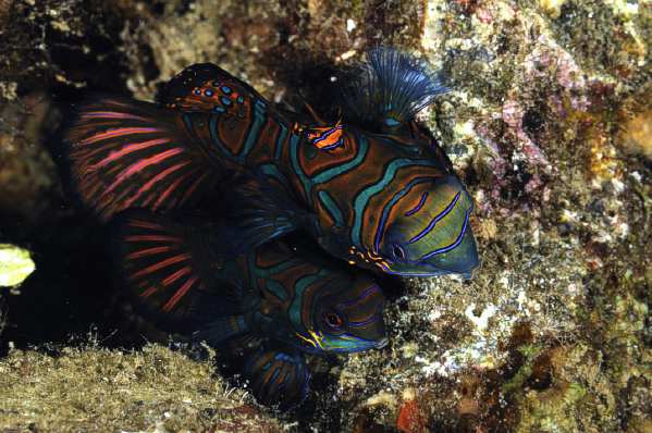
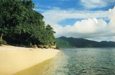
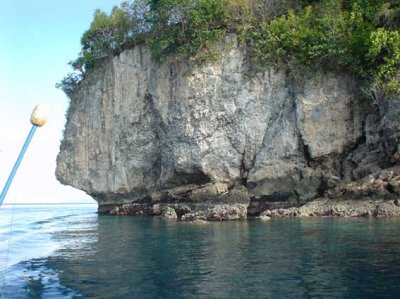
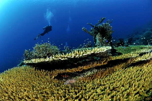
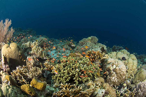
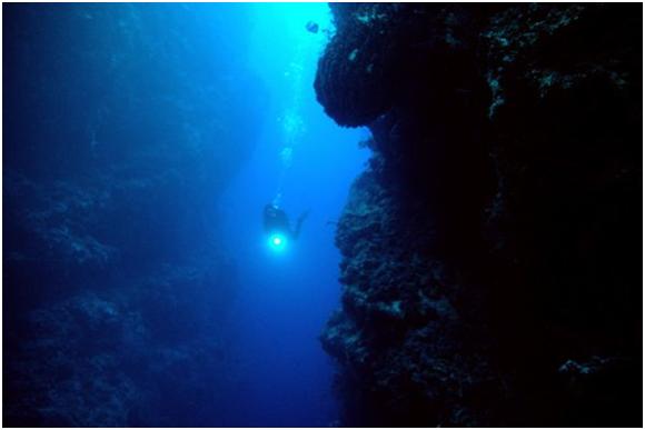
Banda Islands is not only known to have well-preserved old town of the XVIII and XIX century, but also known as a place with incredible underwater sea park that attract divers and snorkeling enthusiast. The beautiful Napoleon fish and Mandarin fish are the most wanted animal to the divers that can be found here easily. The existance of those fishes supported by the finest microbiology in Banda Sea, as a main nutrition to form corals and other marine biota.
During 2001 and 2002, The Conservancy comitted ecological study in Banda island. There are 310 reef-building coral and 871 fish species, include shark and grouper. It proposed as a World Heritage Area. Lucipara island is one of the clusters of Banda island, surrounded by white sand as a turtle habitat.
Transportation and Accomodation
We can reach Banda by flying or boating. We can use Pelni ships which depart every 2 weeks or local sailing route using local boat or speedboat from Ambon. We also can use Merpati Airline to travel to Banda from Ambon. We can spend the night at Laguna Hotel, Maulan Hotel, Mutiara Hotel or Delfika Hotel, and also enjoying Namasawar Restaurant.
 Kapoposang island is famous underwater tourism in South Sulawesi, where we can dive, snorkle, or fishing while we enjoy the landscape. It has one of the best fishing spot in Indonesia. Kapoposang island is one of the island in spermonde at Makassar Strait. Administratively located in Pangkep District, South Sulawesi Province, about 68 km from Makassar City. Kapoposang Islands Underwater Park consists of 3 island, Kapoposang island, Papandangan island, and Gondong Bali island. There are also Suranti island, Pamanggangang island and Tambakhulu island with their beautiful white sand.
Its condition support to become the best diving spot in South Sulawesi. Divers can find heaven in this area with hard or soft coral, coral fish and invertebrates. Uncontaminated and clear water conditions, has attract various types of colorful fish and dancing cheerfully likely welcoming travelers. Few spots become favourite divers, such as Cave Point, Shark Point, and Turtle Point. Other spots like Tanjung Point and Aquarium Point offering divers to interact with wrasse (small fish) who played between soft koral dan reef.
In the south, we can find big atoll called Takabakang. Strong current makes Tuna, Schooling Grouper, Giant Trevally, and Cod visiting this spot. That's why this spot become favourite fishing spot and spear fishing.On the other side of Kapoposang island, we can find turtle habitat and we can (only) watch them. Hawksbill turtle (Erethmochelys imbricata) usually laying their eggs in the sand of Kapoposang island between December-April. Unfortunatelly, there is no captivity for this rare turtle who vulnerable to human distraction or predators.
We can watch, taking picture, even touching these turtle in their natural habitat in Turtle Point. To do that, we have to swim about 500 meters and dive about one and a half hour in this spot. We can find them swim arround or resting in cave in the reef.
PT. Makassar Tirta Wisata providing resort completed with restaurant and sport facilities for tourists, or we can use homestay and dive resort who run by locals. We can also rent cruise ship of 20 tons weight to take us to diving spot and favourite fishing spot. Diving facilities usually operate from Makassar City. They'll give us pleasure by dropping us off onto spot where we can meet pelagis fishes such as Tuna, Shark, or sea mammals (whales & dolphines) that cross by. They offering shallow dives and dives in within 5-30 minutes from resort.
We can access this magnificent place from Paotere harbour within 6 hours or using speed boat from POPSA dock within 3 hours, both of them in Makassar City, from Kalibone dock in Maros District within 7 hours, and 8 hours from Tonasa dock in Pangkep District. To go to Makassar, tourists can use airlines (domestic or international) from Jakarta, Surabaya, or Denpasar
 Padaido is an archipelago in southeast Biak island, Biak Numfor District, Papua Province. This was called Schouter islands named after William Schouter, Nederland sailor who discovered this islands in 1602. Padaido means beauty that can not be disclosed. Padaido consist of 30 small islands and has the world's largest coral ecosystem.It has 95 species of coral and 155 species of fish, including reef sharks and octopuses.
This islands has beautiful beaches and various types of habitats such as atolls, reef edge, and underwater caves. Padaido Islands has reef flats 9,252.1 square hectares and 328.2 hectares deep reef. Divers said Padaido is the most spectacular coral reefs in the world, it's like haven for snorkling lovers or diving experience.
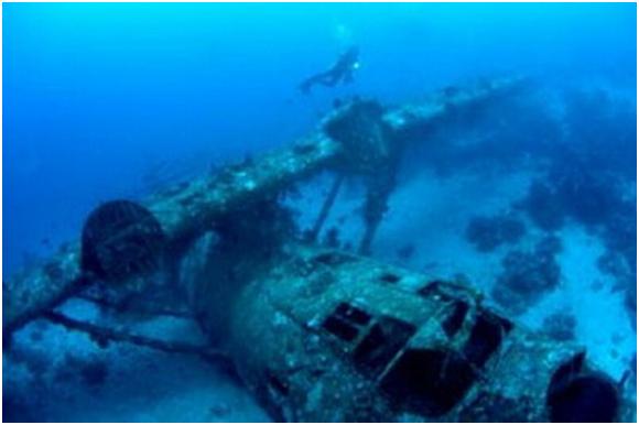
Favourite island are Ureb island and Mansurbabo island which had white sand and clearly water to see through seabed. Underwater caves are chalenges to be explored, besides carcasses of ships, planes, and tanks which become home for coral reef and other species.
From Jakarta, tourists can use direct airline to Biak Numfor. It takes an hour motor-boating from Bosnik harbour or about 3-4 hours using canoe to reach Padaido.
Local government developed this area into diversification of fishing activities, such as fishing tours using traditional fishing boat, dive tour packages arround carcasses ships, planes, or tanks, and also regional cruise using Phinisi boat and sea-plane to reach remote islands.
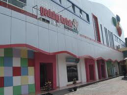
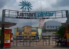 Yogyakarta or Jogja known as student city because many university-level education in the various regions so we can easily found it. For that, education is the main issue in this city. Local authority capture the need of it, and in 2003 they built Taman Pintar near fort Vredeburg complex as a means of expression, appreciation and creation in a fun atmosphere. The main object is to develop the interest of children and young people to science through imagination, trials, and games in order to obtain qualified human resources. This building inspire by the famous educational icon, Ki Hajar Dewantara, who said (in javanese) Niteni, Niroake, Nambahi means to understand, to follow, and to develop.
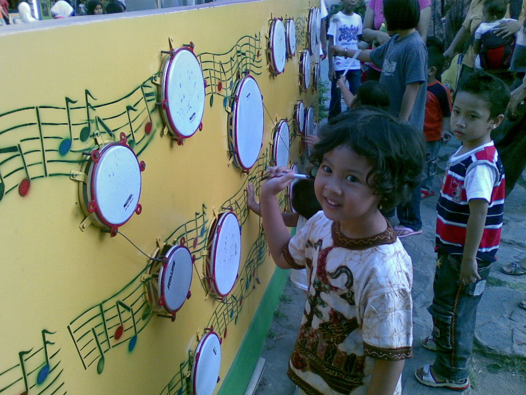
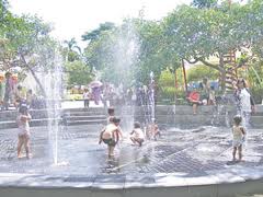
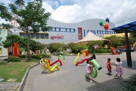
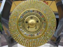 Taman Pintar has hugh area with several section, they are: Playground:Welcoming and games area and also functionalized as public space. After entering the gate, we're greeted by water corridor with Peace Gong at the end of corridor. Gong is one of gamelan component, and this gong represent peacefull condition in Indonesia. We also can find some educational games such as Story-telling Pipe, Wishpering Plate, Tree House, Dancing Fountain, Water Corridor, Picturesque Village, Color Spectrum, Singing Wall, Pulley System, Shaking Bridge, Teeter, Sand Palace, Stone Forum, and Engklek (traditional javanese games). Heritage Building:This area is intend for pre-school and kindergarten. Completed with educational computers and interactive games to develop their skill and knowledge.. Oval Building:This area devided into Exhibition Zone, Exposure Zone, History Zone, and Science Zone. We can actually study in this area by read, listen, and interactive with existing tools. Kotak Building:It has three floors and the most complete zone in Taman Pintar. In 1st flor we can find exhibition area, audio visual chamber, kid's radio station, food court, and souvenir center. We can find basic science and its application in 2nd floor, such as My Country Indonesia, Science Bridge, Populer Technology, and Library. Top floor (3rd) consists of Science Laboratorium, Animation and TV, 3D Cinema Theatre, and Courses Class. Facility:- Interactive science tools - Exhibition and audio visual area - Food court - Mosque - Souvenir Shop - Information Center PS: Do not visit on Monday, they're close.
 Is that real?
Courious with the statement??
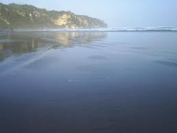
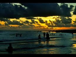
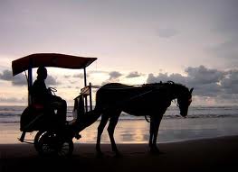
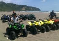
Parangtritis Beach is famous beach in Bantul District, Yogyakarta Province about 27 km southern Jogja City. Public transportations toward location available untill 5 PM. Its known in domestic tourists for the beauty and the legend. A lot of tourists come to this beach to watch the sunset. Not just beatiful sunset, its provides a lot of fun, such as horse riding, bendi or horse-drawn carriage, rent ATV or we can play kite with children, eventhough we never had experience on it.
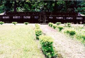
We can see the hole area of Parangtritis, from south to the horizon, through the cliff called Gembirawati. There also Gembirawati temple on the eastern of the cliff. This temple only few meters from shore. To reach this site, we can pass the ramp near Queen Hotel than straight to west about 100 meters. If we want to stay for a while, we can find lodgings or hotels to spent the night.
Its beauty, calls for photographers to capture the opportunity, such as pre-wedding session. This beach also used by the Royal of Jogjakarta Sultanate and locals to held ceremonial associated with Ratu Kidul, whom believed to be the ruler of the ocean. Since this beach known as the gate to the Ratu Kidul empire, the queen seek someone with green clothes to be her maid through this gate. For that, this beach known as beach without tourists dressed in green.
Now our curiosity has been answered, isn't it?. There is no hidden intention, just a mere expression.
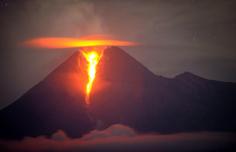
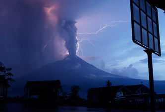
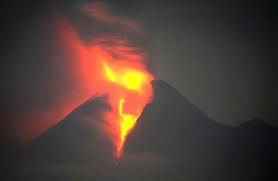
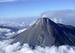 Mount Merapi is one of the most active mount in the world. Since 1548, this mountain has erupted 68 times. This mountain located in 4 districts within 2 provinces. Mountain's slope in the south side included in the territory of Sleman District, Yogyakarta Province, the other side included in the territory of Central Java Province. They are Magelang District on the west side, Boyolali District on the noth and east side, and Klaten District on the southeast.
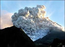
Eventhough this mountain is active, it never devoid of climbers and tourists to visit Gunung Merapi National Park in the height of 2,968 meters above sea level. The most dangerous thing about this mountain is the hot cloud that came out when its erupted, who has already taken so much lives. This cloud contains hot gas, volcanic ashes, and rocks comes with eruption, also known as Pyroclastic flow. Locals called it "Wedhus Gembel" or sheep, because of its shape. When it comes out, the temperature extremely high about 1,000 degree Celcius in top of mountain and about 600 degree Celcius below, and it has speed of lighting to decline from top of mountain, about 200 km/h. Its swept everything while descending from top mountain, trees, houses, even its caretaker "Mbah Maridjan" became victims of it. But, this eruption did not scare locals. They believed that the eruption is common natural phenomena and brought prosperity to them. Mount Merapi is the most popular climbing object, because of its view. Common and closest route is through north side from Selo, Boyolali District, Tlogolele village to be exact. This village located between Merapi mount and Merbabu mount. Through Selo, climbers will reach top of the mountain within 5 hours. There are alternatives routes, through Kaliurang in Sleman District (south side), Sawangan in Magelang District (nothwest), and Kemalang in Klaten District (southeast). Kaliurang route is more steep than the other and took at least 6-7 hours to reach the top of the mountain. 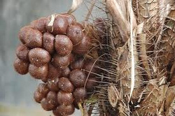 The typical product of this territory is salak fruit, and the most famous are salak Pondoh and salak Nglumut. This species can not grew in other places. If they forced to plant in other places, the fruit does not taste like original one. According to the farmer, whom i speak to, the unique taste of this fruit came from the soil. It contains ashes and sands that came out from mount Merapi. Beside farming, Merapi sand is also known to use as construction materials.
 Senggigi Beach from different angle Lombok is the island on the east side of Bali island. Lombok and Bali has something in common, beautiful beach. Senggigi Beach is one of them, which located in Senggigi region in Mataram District.
Senggigi is about 15-20 min north of the outskirts of the island's capital Mataram and the Selaparang airport. Airport Taxis are available for arriving passengers and charged by fixed a price coupon system charge. The current charges are Rp 57,500 to central Senggigi from the airport.
In daylight hours the a public bemo will cover the distance for around Rp 2,500 from near the airport entrance gate to Ampenan market, and then another Rp 5,000 for a second bemo up the coast to Senggigi, plus extra charges for any larger items of luggage carried.
Town of Senggigi spreads along nearly 10 km of coastal road. This road continues north to Bangsal, gateway to the Gili islands. On the way, expect a fantastic landscape of the northwest coast of Lombok. Most travelers start or end their stay in Senggigi because of easy access to the airport of Mataram and accommodation is available for all budgets. If you are thrifty and without fear and take the ferry from Bali slow, it is best to arrange transportation in advance at the ferry dock in Senggigi and Lombok platform of the page is in a remote location several miles south Mataram.
Senggigi Beach Lombok is the most developed area for tourists on Lombok. You can find a variety of restaurants, bars, discotheques, travel agents, photo processors, money changers, souvenir shop and a range of accommodations starting from budget guest house to 5 star hotels. Restaurants and small cafes line the colorful main beach road. Swimming off the beach is safe. The nightlife and restaurants are concentrated in Central township in Senggigi. For the first time visitor should be aware of these various regional differences. Just book the hotel in Senggigi could mean a relatively remote location in the center of the city can only be reached by taxi or public transport.
Tourists can get to Lombok by air or by sea. Merpati Airlines, Indonesia Air, Trigana Air and Trans Nusa providing services from I Gusti Ngurah Rai Airport (Bali) to Selaparang Airport (Lombok). From Jakarta we can use services from Garuda Indonesia, Batavia Air and Lion Air. Silk Air arrived with tourists from Singapore and from Malaysia with Merpati Airlines. Tourists who like water trip can use ferries call Perama Tours or fast boats like Gili Cat, Mahi-mahi and Blue Water Express from Benoa Harbour, Bali.
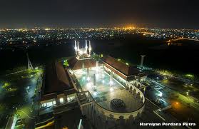
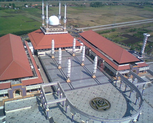
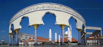
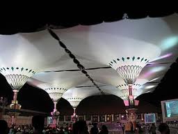
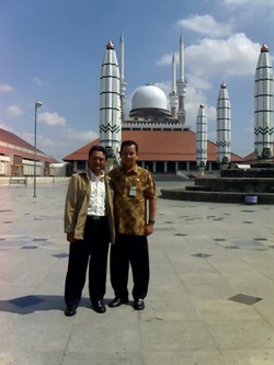 The Great Mosque (background) The Great Mosque of Central Java is a building that influence by The Mosque Nabawi in Medina, located in Street of Gajah Raya, District of Gayamsari, Semarang City. It was built on 2001 and finished in 2006 and spent at least 198.692.340.000 rupiahs. This is the second mosque with giant electronic umbrella after The Mosque Nabawi. This mosque standing in 10ha complex completed with many facilities, such as convention hall, office, spaces for rent, souvenir shop, cafe, library, and tower.
In the first place, this mosque hopefully could control economic social life which tend to wordly-minded. The President of Indonesia attending the opening ceremonial of 198.692.340.000 rupiahs mosque and sign the inscription plate on November 14th, 2006. This plate as high as 3.2 metres and 7.8 tons of weight, comes from Merapi Mount and carved by Nyoman M. Alim who built Borobudur miniature in Minimundus, Vienna, Austria (2001).
Main bulding of the mosque is 7,669m2 and 7,500m2 courtyard to accomodate approximately 15,000 people. There are 6 giant umbrella that can open or close electronically to protect against sun. The architecture of this mosque is a blend of Javanese architecture, Arabic and Greek.
Convention Hall that located in right wing can accomodate 2,000 people. In the left wing there is library (digitall library in the future) and spaces for rent. Besides of the place of worship to ALLAH SWT, this mosque is also providing tourism on religious stuff, education, and center of syiar of Islam. For that, this complex is completed with 23 rooms hotel to accomodate pilgrims.
Besides of the mosque, magnetism of this complex is Al Husna Tower located in southwest of the mosque. It represent the mightiness and supremacy of ALLAH SWT, so that it has height 99 meter as many as ALLAH's Name. DAIs Radio Station located in the ground floor of Al Husna Tower, and Islamic Culture Museum located in the second and third floor. Rotate Moslem Cafe is located in 18th floor and there is 5 binoculars on top floor (19th) to see Semarang City. Rukyatul Hilal, to see and located first moon, also conduct in top floor using Boscha binocular to determine 1st Ramadhan and 1st Eid.
|


 RSS Feed